|
· The Manhattan mobility model usually used to emulate the movement pattern of mobile nodes on streets defined by maps. It can be useful in modeling movement in an urban area where a pervasive computing service between portable devices is provided.
This model also uses its own map. The map is composed of a number of horizontal and vertical streets. Each street has two lanes for each direction (north and south direction for vertical streets, east and west for horizontal streets). The mobile node is allowed to move along the grid of horizontal and vertical streets on the map. At an intersection of a horizontal and a vertical street, the mobile node can turn left, right or go straight. This choice is probabilistic: the probability of moving on the same street is 0.5, the probability of turning left is 0.25 and the probability of turning right is 0.25. The velocity of a mobile node at a time slot is dependent on its velocity at the previous time slot. In addition, a node’s velocity is restricted by the velocity of the node preceding it on the same lane of the street. The inter-node and intra-node relationships are the same as in the Freeway model. Thus, the Manhattan mobility model is also expected to have high spatial dependence and high temporal dependence. It also imposes geographic restrictions on node mobility. However, it differs from the Freeway model in giving a node some freedom to change its direction.
In proposed simulation scheme for Freeway and Manhattan in they did not describe the nodes behavior when it reaches the simulation boundaries. In our simulation method when a node reaches boundaries of the simulation area, it chooses the opposite lane and turns back on the opposite lane. This can solve the simulation boundary problem. The Manhattan map used in our simulations is shown in the follwoing figure.
While model parameters are similar to the freeway parameters, its map has its own parameters:
- dir12lanespace determines free space between two lanes in a street.
- hlines presents horizontal lines.
- vlines presents vertical lines.
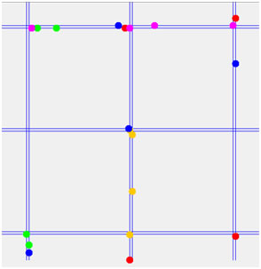
Nodes' movement in Manhattan Mobility Model
Square Reflect Map: It is a square map which has a reflective border. It has an extra handle  managing the symmetric border size. Note that border neither can be zero nor can cover an area more than area of map. managing the symmetric border size. Note that border neither can be zero nor can cover an area more than area of map.
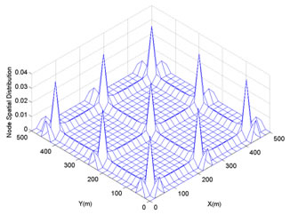
Spatial Node Distribution in Manhattan Mobility Model
· In the Manhattan map editor, handles define the horizontal ( ) and vertical ( ) and vertical ( ) lines. You can add, remove, or move these handles, but note that these handles must be in the map area. Manhattan map handles have a parameter specifying whether the handle is for horizontal lines or not. ) lines. You can add, remove, or move these handles, but note that these handles must be in the map area. Manhattan map handles have a parameter specifying whether the handle is for horizontal lines or not.

Manhattan map MapEditorr window |